
View from Männlichen into the Grindelwald valley
In German, the word for hiking is wandern, and can be expanded to mean anything from migrating, journeying and wandering. And indeed, you can do quite a lot of hiking in Switzerland simply by wandering from signpost to signpost on the country’s 50,000 km of marked trails. Even the smallest mountain outposts are easily found via an intricate system of wanderwege routes (marked by yellow signs) found between lakes, valleys and towns, higher altitude bergwege mountain paths (marked by white-red-white blazes), and rugged alpine routen trails (marked by white & blue blazes) that can include steep drop-offs and sections with cables or handholds.
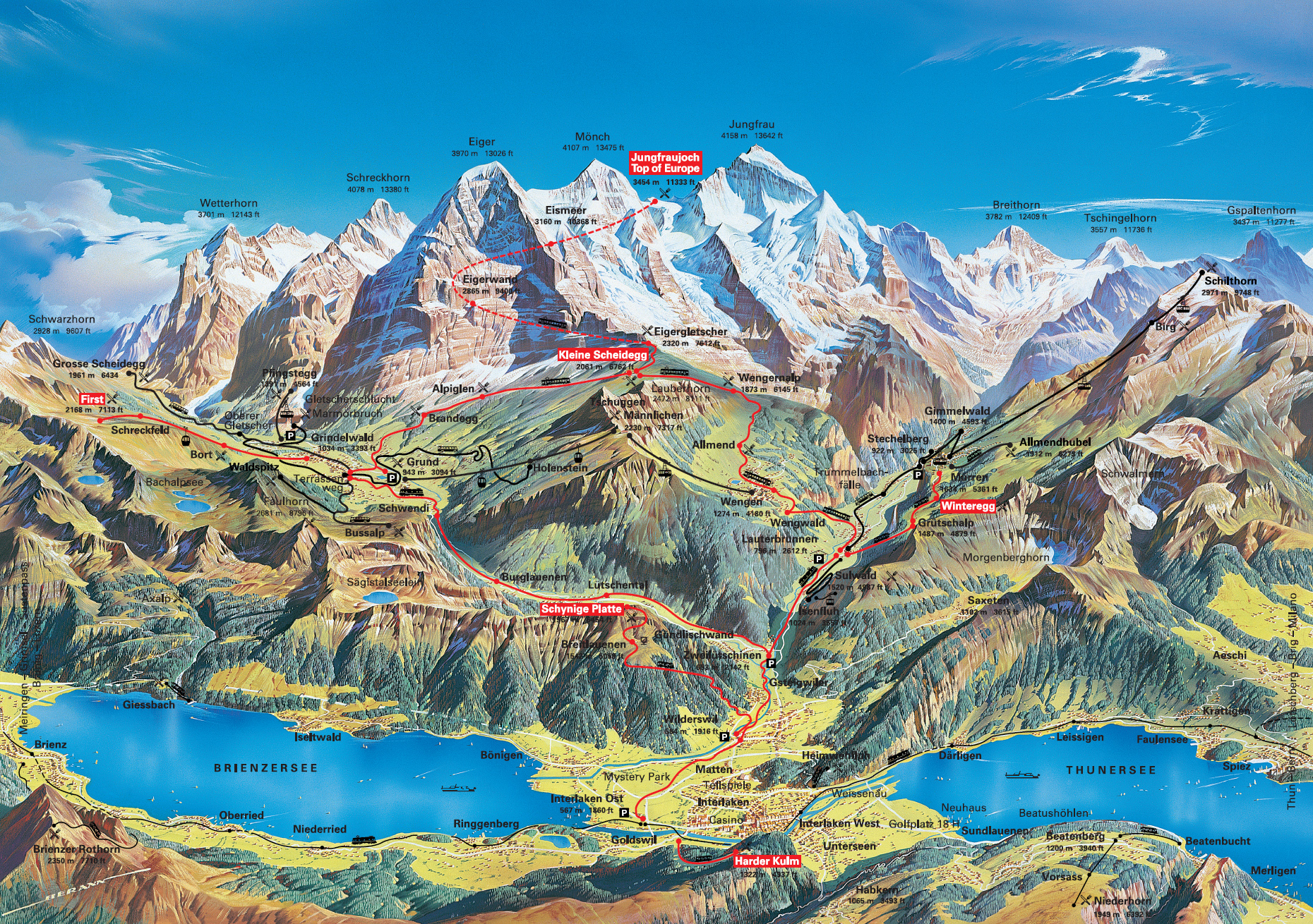
Since the phrase “relaxing vacation” is not in our vocabulary, Britton and I spent our last day in Berner-Oberland hiking. The guide at Balmer’s suggested taking the train from Interlaken to Wengen (with a train transfer at Lauterbrunnen). Round-trip tickets for this cost about CHF 25. From Wengen (1,274 m), we would hike the route to In Gassen and Männlichen (2,227 m), then walk along the mountain ridge to Kleine Scheidegg (2,061 m), and finally trek downhill from Kleine Scheidegg toward Wengernalp back to Wengen. On the Jungfraubahnen Wandern map, that would be routes 46, 33 and 41.
The morning was marked with a heavy downpour and ominously thick cloud cover, and I silently fretted about what we were going to do if the rain didn’t ease. Fortunately, the skies cleared at about 10:30 am, and we set off with backpacks full of bread, cheese, salame and light clothing. Personally, I think that hiking in sneakers is often safer than using thick-soled hiking boots because you will have a better feel for the terrain. Besides, hiking boots are heavy, and that extra weight goes a long way when you are scaling a mountain. The same goes for hiking poles; they can be helpful if you’re going downhill, but for the most part, you’re better off using your hands for balance and feet to feel the ground. I had to laugh at the hikers decked out in shiny layers of North Face and poles on flat sections of trail. Newbs.


Obfuscating clouds still covered the skies when we hopped off the train at Wengen, and the top of the Männlichen summit was completely shrouded. We stood at the bottom and shrugged at the task ahead of us, mostly because we couldn’t see what was ahead of us. From Wengen, there are multiple paths to Männlichen but the road less-traveled is the steeper, slightly shorter trek going towards In Gassen. At one point, we lost the trail and found ourselves in the middle of a field surrounded by cows. “Is that the trail, or is that just matted grass from the cows?” Britton wondered aloud. As we gingerly stepped around the cowpies, we spotted a blaze on a tree on the opposite side of the field. Hmm, our guide did say that not too many people take this trail, I wonder why…
Over two hours later, we were still huffing and puffing up a never-ending series of S-turns, on a narrow, single-file trail with rain-slicked rocks and sharp drop-offs into the valley one side. One section of the trail included a cable hand-hold. It was, as our guide had mentioned, just “a little steep.” Fog was rolling in and out around us, which might have been for the best since it hampered our ability to look down. We began seeing a series of brownish-red fences planted on the face of the mountain in tiers. “Is that for catching people who fall?” said Britton. We pondered the ramifications of taking a false step off the trail. (Later, I found out that the fences are there to control snow drift and prevent avalanches in winter.)

Eventually, we stumbled to the top of Männlichen, where we were winded, sweaty, ravenous… and surrounded by dozens of tourists who simply took the gondola to the summit. “Whatever, they can’t say that they hiked a 1,000 meter ascent today!” I said lightly. Besides, we were rewarded with a breathtaking view of the other side of the mountain. Dotted with small lakes and crossed by ski trails, you could see Grindelwald at the foot of the valley and hear the serene tinkle of cowbells. No wonder the Jungfrau region is a UNESCO World Heritage Site.
There is hot food available from the canteen at Männlichen, but since we’d packed lunches, we simply strolled inside to make use of their tables and bathrooms while resting in warm environs.
From Männlichen to Kleine Scheidegg, the trail is gloriously wide and flat, with lots of older people and kids hiking the path. The entire time, you have a panoramic view of the Grindelwald valley, with the Eiger, Mönch and Jungfrau peaks ahead of you. It is without a doubt one of the most beautiful places on earth.


Clockwise: flowers sprinkled on the mountain; an unsupervised, roving band of goats waits to cross the train tracks in Kleine Scheidegg; Switzerland’s highest peaks keep their snow caps even in August
Kleine Scheidegg is the pass between the Grindelwald and Lauterbrunnen valleys, and you can take the train from here to Jungfraujoch (3,454 m), popularly known as the “Top of Europe” since it is the highest elevation that is still easily accessible to visitors not equipped with serious climbing equipment. The catch is that the round-trip train ride to Jungfraujoch will cost about CHF 58 from Kleine Scheidegg, or CHF 159 from Interlaken. And actually, at 4,158 m, the Jungfrau is not the highest peak in Switzerland. That honor belongs Monte Rossa at 4,634 m, which lies between the Swiss and Italian borders.
After the intense morning, the trek from Kleine Scheidegg downhill to the other side of the mountain was a relaxing denouement. The path here is fairly wide and mostly gravel, and is used as a ski trail as part of the Alpine Ski World Cup. In the summer, you can also mountain bike down, though this might be less appealing if you value your health. As we left Wengernalp (1,873 m), we paused to look across to the mountain we had climbed earlier that day. The Männlichen gondola station was an almost imperceptible dot. Had the skies been clear that morning, we probably would have had second thoughts about hiking up.


Immediately before Allmend, there was a farmhouse with a chalkboard sign outside, proclaiming “We sell cheese.” Never one to pass up potentially tasty detours, I flagged down the farmer and his wife, who gave us samples of their mutschli, a semi-hard cow’s milk cheese aged for 5 weeks. It was smooth, firm and nutty, made with the milk of the farm’s 26 cows who were wandering about outside. We ended up buying a quarter wheel for CHF 7.
Once back in Wengen, we sat down gratefully on a train seat for the hour-long ride back to Interlaken Ost. At that point, Interlaken seemed about as flat and low-lying as the Great Plains.
Total suggested hiking time, excluding rest stops: 6 hours, 35 minutes.